
Last weekend, we crossed the border for an overnight stay in what’s probably my favorite small town in the U.S.
Bellingham, Washington. The friendliest human ambience. Proximity to nature. Wooded trails where everybody says hello when passing by. Strong civic pride among committed residents. Highly successful urban renewal placing value on heritage preservation and creative commercial reuse in the city’s two downtown cores of Bellingham and Fairhaven. (Love Port Townsend? Yep, you’d love it here too.) Excellent restaurants, especially if you want your choice of Mexican food. And the best bookstore north of Seattle, Village Books: venue for last summer’s Steampunk Festival and a generous stream of other events before and since.
In fact, in June 2016, Bellingham had the distinction of making the landing page of 24/7 Wall Street’s “50 worst cities in America to live in”: clearly high praise when you consider that New York, San Francisco and Boston also made that list.

I’d visited Bellingham many times before, but this time round I had a fairly specific motive: walking the Bellingham Interurban Trail. Aside from my general fascination with rails-to-trails (because obviously they’re among the coolest things ever), I wanted to see what this established 6.6-mile railroad conversion could teach Vancouver in developing the Arbutus Greenway, the subject of much of my own advocacy over the last few months.
A forest, a creek, a 50k race
The Bellingham Interurban is a north-south trail along the former right-of-way of a Bellingham–Mount Vernon electrical passenger line built in 1912 and decommissioned in 1930. The railway’s trajectory forms a poignant testament to an era when much work went into building short-lived local trains. Happily for the community, the line earned permanent life through its designation as a rail-to-trail in 1987. It originates in the Fairhaven historic district, passing through the canyon-filled woodlands of Arroyo Park to terminate at Larrabee State Park to the south.
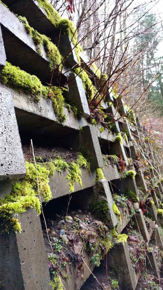
With some concrete trestle footings as historic remnants, the Interurban has a surface of hard-packed cinder and a number of convenient access points along the way. Here’s a map in case you want to hike or bike it yourself.
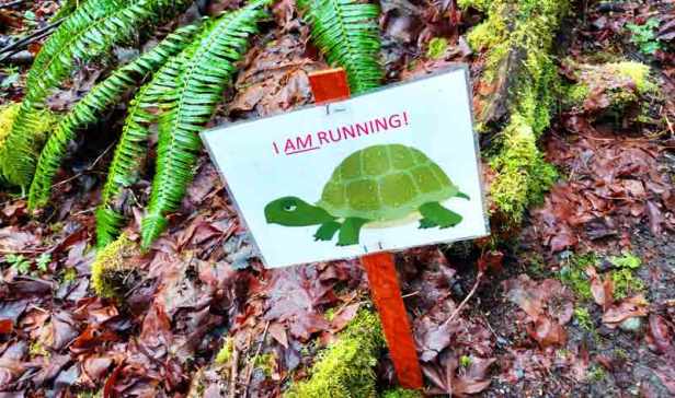
For our walk, we started at 10th and Donovan in Fairhaven and did about half the trail before running out of time and turning back. It was Saturday, March 18, and the Interurban was fairly busy thanks to the Chuckanut 50k race, on its 25th run. Funky little motivational signs stuck along the trail encouraged runners to reach the end.
From Fairhaven, the Interurban takes you along Padden Creek. Submerged under a tunnel starting in the 19th century, the creek has been the subject of a 2015 daylighting project to encourage restoration of its ecosystem, as signs along the Interurban explain. (Daylighting has to do with the re-exposure of waterways formerly diverted into culverts during development. Interestingly, this has made recent news in Vancouver as well, with the proposed restoration of our own Tatlow Creek.)
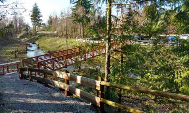
A wide, level train bed passing by a variety of plant systems, streams and remnants of old railway embankments, the trail leads into narrower footpaths full of switchbacks running through mossy Arroyo Park. It also takes you right beside Padden’s salmon ladders. I would have loved to continue on and see the train bed pick up again to feed into Larrabee State Park, but that remains for another trip.

Bringing it home: The Arbutus Greenway
What can we take from this as Vancouver builds its own railroad conversion?
In the past I’ve spoken of Arbutus as a rail-to-trail, but the visit to Bellingham helped me to appreciate that it isn’t one in the true sense. As emphasized both in public forums and in the RFP recently published for contracting work on the greenway, the City of Vancouver purchased Arbutus with the intention of turning it into a transportation corridor accommodating an eventual streetcar. By contrast, the Bellingham Interurban epitomizes the type, as reflected in its listing by the Rails-to-Trails Conservancy. So the analogy between Bellingham’s pathway and the much more urban Arbutus is far from exact.
That said, there’s a lot we can learn from the Interurban’s successes:
Multipurpose use
The combination of the 50k race and the ecosystemic context provided along the trail (by the signage about the Padden Creek daylighting, for instance) brought to my mind the opportunity to bring together recreational, environmental and educational experiences along Arbutus through events, informative installations, public art and more.
Community
The sense of camaraderie along the trail – with even the most exhausted joggers smiling and saying “Hi” as they passed – affirmed for me the potential of Arbutus to bring Vancouverites together out of social isolation and into the community: indeed one of the most vital aspects of its value as a public space, as emphasized by some of the greenway stakeholders during the recent consultation I attended.
Connectivity
A super-important asset of the Bellingham Interurban is the connectivity it creates among different parks and between parks and urban areas. Public space is a network. It’s not just the nodes that matter but the connections also, and a trail like this – and like Metro Vancouver’s Central Valley Greenway – provides the perfect means. The Bellingham Interurban stitches the area’s jewels together, with neighborhood access paths that are plentiful and easily attained. Depending on where you live as a resident, you can use the trail to visit a friend in another neighborhood, visit the Fairhaven historic village green or take a walk or your mountain bike through the woods. Such connectivity should be a principal objective with Arbutus, as a means of opening up the city’s green spaces, neighborhoods and commercial pockets while also getting people out of cars in accessing them.
Anyhow, I’m pretty excited to course through the Interurban’s southern stretch on my next visit to town. More about that when I do.
